


Inca Trail Elevation – The High-Altitude Trek to Machu Picchu
The Inca Trail is one of the most iconic trekking routes in
the world and the most popular trail taken by tourists venturing to the
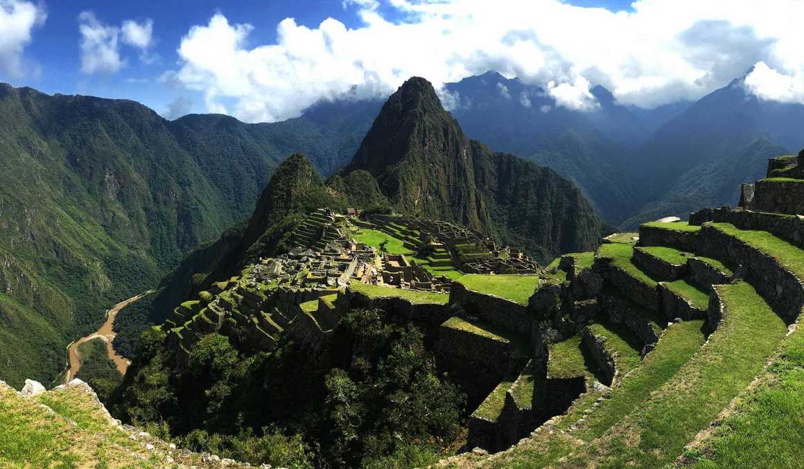
magnificent ruins of Machu Picchu. Starting at the Kilometre 82 gate (so called
because it is 82 kilometres from Cuzco by train) the scenic trek to Machu
Picchu on this 4-day route is 42 kilometres (or 26 miles) long, winding through
the stunning Andes Mountains.
When most people think of the Inca Trail to Machu Picchu,
they see the ancient citadel as the high point, both figuratively and
literally. Whilst figuratively this is generally true, in terms of altitude,
Machu Picchu is certainly not the highest point on the trail. But how high is
Machu Picchu? And what is the true high point on the Inca Trail?
In this post we’ve detailed what you can expect on your trek
in terms of elevation climbed each day on the Inca Trail, the highest point of
the trail, how difficult it is to trek to Machu Picchu and how to limit your
chance of getting acute mountain sickness.
So, if you’re planning a trip to Peru, read on to find out
more!
Elevation on the Inca Trail – Day by Day
Most Inca Trail treks (including all of ours) begin at
Cusco, which, at 3,400 metres, is already considerably higher than Machu
Picchu. By staying there prior to your trek, you will give your body time to
acclimatise to the Inca Trail altitude.
The Inca Trail elevation varies greatly throughout the trek
and your body will notice the differences, especially at the higher points.
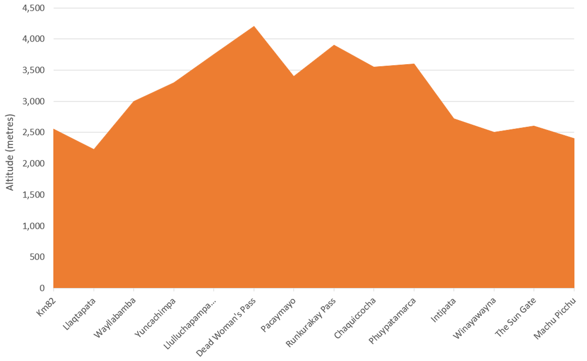
The Inca Trail to Machu Picchu begins at a place called
Kilometre 82 at 2,600 metres and descends slowly downwards during the morning
before ascending in the afternoon to Yuncachimpa at 3,300 metres. Although this
is a high enough altitude to bring on altitude sickness, if you have spent
several days in Cusco beforehand you should be fine at this point.
The second day is the toughest on the Inca Trail. The first
4 kilometres are steep and take approximately 2 hours as the trail leads
through the Valley of Llulluchapampa at 3,750 metres. From here, the path
continues less steeply for another 2 hours, ascending up and over Abra
Warmihuausca or ‘Dead Woman's Pass’ at 4,200 metres. Your body will almost
certainly feel the effects of the altitude here as the air is providing less
oxygen than your body is used to.
You do not spend long at this altitude as the trail
continues down a long and steep descent to the Pacamayo River before continuing
on to the summit of the second pass, Runkurakay Pass at 3,900 metres. The rest
of the day is spent descending down to 3,600 metres where you camp at
Chaquiccocha.
From Chaquiccocha it is generally easy going as you descend
to the Sun Gate and then Machu Picchu where the Inca Trail comes to an end.
Below we have provided an altitude graph for the Inca Trail.
Highest Point of the Inca Trail
The highest point on the Inca Trail is Abra Warmihuausca or 'Dead Woman's Pass' which stands
at 4,200 metres. The pass comes during the second day of the trek and is often
considered to be the most challenging, because much of the day is spent at
higher altitudes and the terrain becomes rockier and more difficult.
The name came about due to the silhouette of the mountain as
you can see the profile of a woman lying on top of the Andes from the pass.
Dead Woman’s pass is a big achievement for many hikers and
reaching its summit is one of the most rewarding moments of the trail besides
reaching Machu Picchu itself. It’s at this summit when many feel a first sense
of accomplishment on the Inca Trail.
Generally, to be affected by altitude sickness, you need to
be above 2,800 metres. Therefore, whilst Machu Picchu is below this point, at
4,200 metres above sea level, Dead Woman's Pass is easily high enough to bring
on symptoms of altitude sickness.
How High is Machu Picchu?
Standing at 2,400 metres, Machu Picchu is one of the lowest
altitude points on the Inca Trail.
Despite this, symptoms of altitude sickness can be
experienced at this height, so precautions should still be taken. When hiking
the Inca Trail to Machu Picchu, your professional guides will check that
everyone is responding well to the altitude and ensure the trek is as enjoyable
as possible for you.
How to Prevent Altitude Sickness on the Inca Trail?
Before trekking the Inca Trail to Macchu Picchu it is
important to be aware of the causes and effects of altitude sickness and how to
treat it if it occurs.
Altitude sickness is not something that should be taken
lightly and severe acute mountain sickness (AMS) can lead to High Altitude
Pulmonary Edema (HAPE) and High Altitude Cerebral Edema (HACE). Both HACE and
HAPE are life threatening unless treated immediately and anyone displaying
symptoms of either should descend immediately.
Less severe altitude sickness generally takes the form of
headaches, feeling of nausea, sickness, loss of appetite and shortness of
breath. These symptoms all result from the fact that your body is not getting
the amount of oxygen into the bloodstream that you're used to. As you ascend
higher the density of oxygen molecules in the thinner air decreases and often
leaves you feeling short of breath.
This is why acclimatisation is key. All trekkers travelling
with Kandoo Adventures will spend at least a day in Cusco before departing on
the trail. This gives your body time to acclimatise which it does by creating
more red blood cells, breathing more deeply and increasing pressure to your pulmonary
capillaries which forces blood into areas of your lungs that lie dormant when
breathing at sea level.
If, on the Inca Trail, you feel the onset of any symptoms of
altitude sickness, it's very important to communicate this to one of our guides
as they will be able to help and advise you on the best course of action.
Getting altitude sickness on the Inca Trail does not mean you will have to turn
back; it usually just means you will either have to descend for a short time or
rest where you are until your symptoms have cleared.
For our full guide on altitude sickness and acclimatisation.
References
NHS | Our own experience